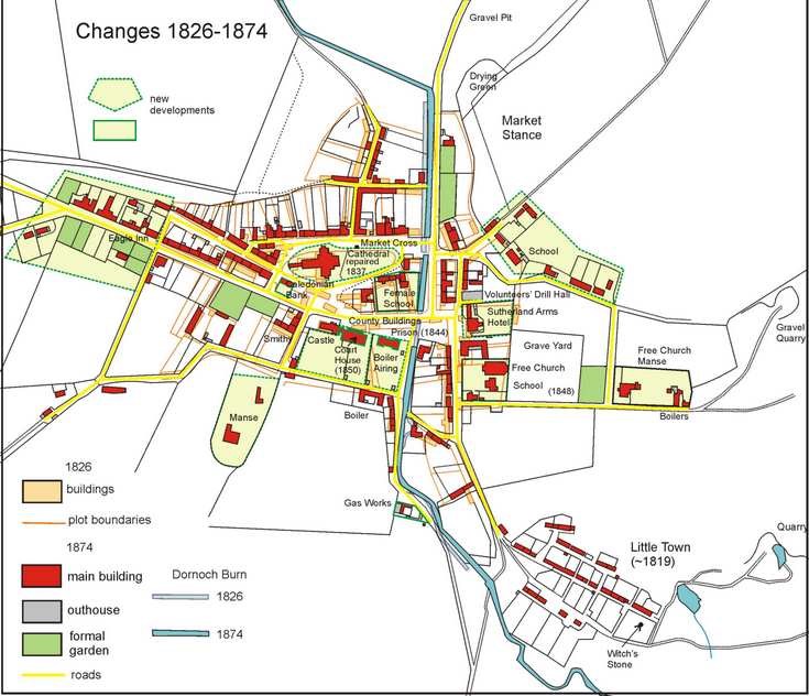
Dornoch developments between 1826 - 1874
This reproduction map shows how the considerable expansion of the town during this period 1826-1874. The map is the result of the first detailed Government survey, carried out in 1874, of this part of Scotland and is extremely accurate. A comparison with the 1826 estate plan (2011.034.03) shows only small deviations of a few metres, indicating how accurate the Estate's surveyor was! The period between 1826 and 1874 corresponded to a great increase in the fortunes of the town due largely to investments by Sutherland Estate. The town was extended westwards by the addition of a group of houses (including the Eagle Inn in 1860) on the north side of Castle Street together with two substantial dwellings with formal gardens on the south side. The Cathedral has been repaired and the nave rebuilt and the properties between the Cathedral and the Castle cleared. The Court House, Prison and Police Station were built east of the Castle. Opposite the Jail, is a 'Female School', the building currently partly occupied by the Dornoch Charity shop.
South of The Meadows, is a new Manse in large formal gardens which until 2009 was the Sutherland County Council offices. The layout of the north side of the town is substantially unchanged. However east of the Dornoch Burn, new houses and a school have been built along Murray Road, and the east side of Bridge Street is now occupied by the Sutherland Arms Hotel (built in the mid 19th century) and the Volunteers' Drill Hall. The Free Church, with its School and Manse was founded in 1848 on the north side of Grange Road. To the south, along River Street, the Clearance settlement of Littletown had been established around 1819 but did not appear on the estate map of 1826.
Dimensions: jpeg file