David Aitken's Plan of Dornoch 1784
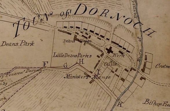
David Aitken's Plan of 1784 is the earliest plan of the town that we know of, produced by David Aitken for Sutherland Estate. This earliest known layout of the town shows at right, to the west of Dornoch Burn, two streets lined by houses routed on each side of the Cathedral, meeting in the west at a point near where the present Eagle Inn stands in Castle Street. . These streets are crossed by a third, at right angles, along the line of Castle Close to the south and Gilbert Square-North Street to the north. The only buildings on this plan that can still be identified are the Cathedral itself and the Bishop's Palace (Castle), together with the site of the Minister's Manse (at the south end of Castle Close). Comparison with the 1826 layout (2011.034.03) (which corresponds in essentials with the present one) is difficult because the 1784 plan is not drawn accurately to scale and orientation. Also, it is not clear whether the houses shown on this plan are accurately positioned or are merely schematic. What is clear however is that the main streets correspond to the present High Street and St Gilbert Street and that Castle Street is a later addition.
This map formed the inspiration for an exhibition at Historylinks during the summer of 2010 covering, with reproduced maps, the development of the town from the 18th century. (see 2011.034.02-08)
Dimensions: jpeg file