Monk's Canal, Rearquhar
Description and map of the Monk's Canal at Rearquhar, mounted on board. Six photos also on the board are numbered separately. Ordnance Survey Grid Reference Numbers: NH79/89: 7445.9125 to 7470.9195; 7480.91875 to 75075.9195 and 759.91625 to 76075.91575.
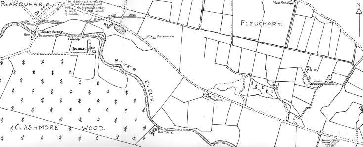
Dornoch Cathedral celebrates, this year (1989), her 750th year of consecration. Water being required for working the flour mill and servicing the developing township, at that time, a channel was cut from the Evelix at Rearquhar to bring running water to Dornoch. The cut was of no mean proportions as can be seen from the photographs today. Certain discrepancies in levels arise now, especially at its point of origin, where the present bed of the channel is seen to be some four feet above the river level. This may be due as much to cutting back of the river, as to infill over the centuries from weathering and the constant movement of animals. The plan shows the three sites, in which the first two, in Rearquhar, have become separated by breaching of the cut by land-slip due to water erosion. Almost all trace, otherwise, has disappeared, through agricultural reshaping of the land, except for a short section further east, at Cnoc Bhair. The best view of all is where the Rearquhar road cuts the old channel a few hundred yards east of Rearquhar School House, and about a hundred yards west of the old Gravel Pit near Gashagich, at O.S. point NH78/79:7485.920.
Dimensions: Width 450 mm - Height 640 mm